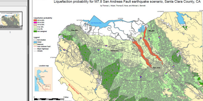
This map shows the likelihood of liquefaction in Northern Santa Clara County during a magnitude 7.8 earthquake on the northernmost segments of the San Andreas Fault. This earthquake is similar to the 1906 San Francisco earthquake. At each location, the map predicts the approximate probability that shallow wet sands will liquefy and cause surface manifestations of liquefaction such as sand boils and ground cracking. Liquefaction is a phenomenon that is caused by earthquake shaking. Wet sand can become liquid-like when strongly shaken. The liquefied sand may flow and the ground may move and crack, causing damage to surface structures and underground utilities.The map depicts the hazard at a regional scale and should not be used for site-specific design and consideration. Subsurface conditions can vary abruptly and borings are required to address the hazard at a given location. The map assumes the historically shallowest water table conditions and does not reflect current ground-water conditions. If the current water table is deeper, the probability of liquefaction is reduced. The map includes the communities of San Jose, Campbell, Cupertino, Los Altos, Los Gatos, Milpitas, Mountain View, Palo Alto, Santa Clara, Saratoga, and Sunnyvale.
High Quality Printable Map
Read more